Chirripo National Park
The Chirripó National Park
The park includes the country's highest mountain, Mount Chirripo, with 3 820 MSN (Meters Above the Sea), which according to the testimony of some Indians was Father Augustine (Missionary of Talamanca Indian Reserve), the first white man who conquered the summit in 1904. Later expeditions occurred in 1905, 1914, 1915, 1920, 1932, 1942, and since then became more frequent.
Weather conditions in the park are highly variable and unpredictable and largely dependent on the altitude.
In general it is very humid from May to December, and become very dry and sunny during the months of January through April.
The highest parts are subject to strong winds, frost, frequent showers and changes in temperature to such an extent that the lowest recorded in the Chirripo and the country has been 9 degrees below zero.
The park was created on August 19 1975, and covers 50,150 hectares. Average temperatures range from 9C below zero to 20C above zero, with an average rainfall of 3,500 mm. Dry season is from January to April. Rainy season goes from May to December.
Access: Through the village of San Gerardo de Rivas along the original trail, 14 km from San Isidro or from the village Herradura via the Uran line. If you are thinking in visit the area is highly reccomended read the page: HIKING TO CHIRRIPO NATIONAL PARK Usefull Information
Temperature: Varies between -9C and 20 C(16 F and 68F)
The average annual rainfall is 3,500 mm (136.5 inches).
Dry months: January through April.
Rainiest months: May through December.
Services offered in the area include: guides, food, lodging and horse rentals to transport equipment to the Crestones refuge.
Vegetation includes orchids, ferns, mosses, bromeliads and palms, and among the animals there are deer, squirrels. pumas, dantas, and jaguars.
And birds such as: quetzales, robins and hummingbirds may be seen.
Chirripo is the highest mountain in the country at 3,821 m above sea level.
The first man to climb to the peak was Father Agustin Blessing in 1904.
There are also 5 areas of beautiful natural landscape and geological and ecological importance:
-Sabana Los Leones
-Los conejos valley
-Morrenas valley
-Chirripo peak
-Los lagos valley
CHIRRIPO NATIONAL PARK
Chirripó National Park is located in the Talamanca mountain range, northeast of the city of San Isidro del General. The park encompasses an area of 50,150 hectares (123.921 acres), and was established August! 19, 1975.
One can access the park through San Gerardo de Rivas. The area's Administration Office is located there. This community is about 29 km (12.5 miles) from San Isidro del 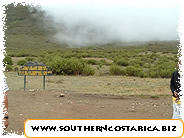 General. From there you have two choices: yon can enter the park taking the traditional 14 km (9 miles) trail, or in the town of Herradura, (on the road to Uria) you can hire a local guide to accompany you on a different, recently opened trail.
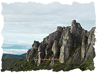
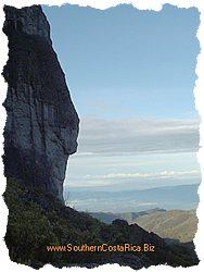
One of the most interesting geomorphologic discoveries found in Chirripó are the various "U" shaped glacial forms. Moraines, glacial terraces, glacial lakes and cirques, are evidence of glacial movement, dating back 25.000 years. The park includes the tallest mountain in the country, Chirripó, which reaches 3820 meters (12.530 feet) above sea level.
According to the stories of the indigenous people of the area; in 1904 Father Agustin Blessing, a missionary, became the first "white person" to conquer the peak. After that, there were formal expeditions in 1905, 1914, 1915, 1920, 1932 and 1942. Since then, trips have become more frequent.
Atmospheric conditions in the park are extremely variable, unpredictable and dependent on altitude.
The highest altitudes are subjected to strong winds, freezing temperatures, frequent showers and dramatic changes
in temperature. In fact, Chirripo has the dubious honor of having had the coldest temperature recorded in the country, 9C (16F).
FLORA AND FAUNA
Nearly 3,400 metes (11.152 feet) above sea level, there is a high barren plateau, on which the vegetation is severely
stunted. There are no trees taller than 4 meters (13 feet) and at times the underbrush becomes so tangled that it blocks
one's passage. One of the most common species found here is the chusquea or cañuela Batamba (Swaiienochioa
subtessellata).
Another life zone is the cloud forest, which is humid and cold. Live oaks, reaching heights of 50 meters (164 feet),
evergreens, schrubs with brittle leaves and small acorn-like fruit,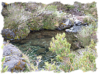 can be observed here. The most common oak is the Quercus costaricensis.
This forest is characterized by many tree-sized ferns, mosses, bromelias, palms and orchids distributed in different altitudes.
Among the animals that live there are: saínos, tapirs, pumas, hares, coyotes, toads, frogs and a huge variety of birds including: jilgueros, hummingbirds, flycatchers, trepadores, reinitas escarcheras, and the stunning, metallic green quetzal. This brilliantly colored bird feeds on a plants, worms, insects and small reptiles and amphibians.
The higher part of the park contains five areas of incredible beauty and geological and ecological importance:
Sabana de Los Leones (the Lion's Savannah).
Cerro Chirripó (Mount Chiripo).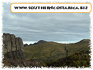
Valle de Los Lagos (Lakes Valley).
Valle de los Conejos (Rabbit Valley).
Valle de las Morenas (Morenas Valley).
Lake Chirripo is located in "El Valle de Los Lagos". At the button of this lake are sediments which have been carbon dated to 2000 bc. These sediments show evidence of ancient forest fires, perhaps started by natural causes, like lightning or perhaps human activities. We have records of recent forest fires in 1953. 1958. 1976, 1977, 1981, 1985 and 1992.
The park protects the upper basin oft he Pacific Chirripo river which flows into the great basin of the Terraba
river, a tributary of the Matina river.
The protection of these watershed areas, with their infinite network of creeks and springs, ensures the availability of clean water downstream.The type of high quality water equally suited for domestic, agricultural, industrial, recreative and hydroelectric use.
Location: 26 km northeast of San Isidro de Perez, Zeledon in the Talamanca mountains. In the left menu you can see a map.
PICTURES
Be the first to comment on this listing!


- City
- San Gerardo PZ