Golfito
First: You will have a good Idea of the distance and the road if you use our 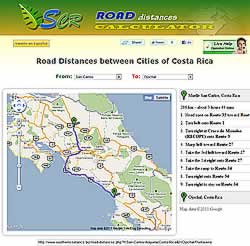 Costa Rica Distance Calculator and Map
GOLFITO
This canton, whose number is VII of the province of Puntarenas, was created by the Decree-law No. 532 in June 10th of 1949
Surface: 1.753.96 Square Kilometers
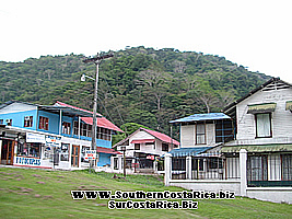
Its principal city name is Golfito
It is 341 kilometers far away from the San José city.
It has four districts which are the following : Golfito, Puerto Jiménez, Guaycará, Pavones or Villa Conte. The principal county of the canton was named “Golfo Dulce” that means “Sweet Gulf” and also Santo Domingo, and in the year of 1949 when the canton was settled it took the name of “ Golfito “ because of its shape in the border of the beach that forms a small gulf in the inner part of the big Golfo Dulce.
 |
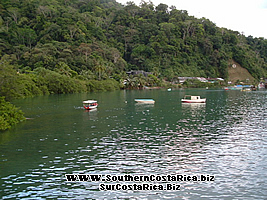 |
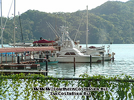
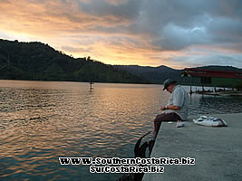
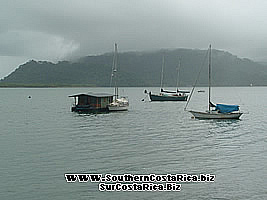
Tourism in Golfito
This place is rich in different tourism options, between them we must mention the fishing due to the fact that there are zones near it where excellent records of fishing have been registered, not only in the size of the product but also in the quantity of them (more information can be found in the activities section of this same web site). Moreover, you can dedicate your day to take a walk so that you can be able to know the greatly beautiful Playas de Zancudo (here I must say that in this place I have had the opportunity of spending my best time of vacations because of the beauty of the place and all the tourism options that it has) and also I must talk about Playa Pavones (excellent for those that love surfing). You can also go to Puerto Jiménez (it is just one and a half hour far away from Golfito if you go in boat) and being there you can travel to the Corcovado National Park. Another place that is near Golfito is the Reserva Indigena (Native Reserve) Guaymie de Conte Brunca and the Reserva Nacional (National Reserve) de Fauna Silvestre Golfito. The information of all these places you can find it completely in this web site, in the section of activities, Beaches and Protected Zones.
 |
 |
Transportation options to Golfito
Bus Schedule, Plane Schedule, Rent a Car services, Taxi.
Hotels
 |
 |
Economy
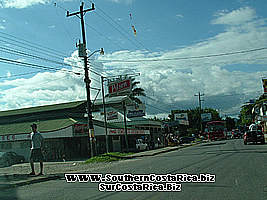
 In this canton some activities of commercial kind are developed: one of them related with the Puerto Libre (Free Port ), other with the commerce in the rest of Golfito where you can find stores, little supermarkets, hardware shops and other. They also develope tourism activities to satisfy the demand of the visitors of the Puerto Libre that have to stay at least one night in the zone, and that is why you can find hotels, cabins, restaurants, fishing tours, boat tours, souvenirs sales, bars and other. In this place, they have also a processing plant of oil palm which together with the production of rice, cocoa, corn, beans and the stock farm become the principal products of the canton.
(For more information about Golfito Options and Business, please visit the Golfito Portal).
Available Services in Golfito
Golfito has agencies of the Banco of Costa Rica, of the INS (National Insurance Institute), there is a hospital, cooperatives, offices of the ICE (Costarican Electricity Institute) and offices of the A y A (Water Services Institute) In Golfito is settled all kind of commerce such as fuel stations, stores, hardware shops, home supplies stores, restaurants, hotels, cabins, supermarkets, bakeries and drugstores. Regarding to the services, you can also find in Golfito services provided by lawyers, topographers, doctors, dentists and fire stations.
Golfito History and Background
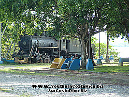
During the Spanish conquer time, the Golfito zone was occupied by natives of the group of the Bruncas whose leader was the Cacique Giriara, who also dominated Turrucaca (55 kilometers away from the coast of the Golfo Dulce toward the inner side of the region) and they were also lands near from the Cacique Osa whose authority was centered 45 kilometers away from the Punta Burica. The region where is located the canton of Golfito was discovered in 1.519 by Juan de Castañeda and Hernán Ponce de León who traveled by sea from Punta Burica to the Golfo de Osa, known now as Golfo Dulce (or Weet Gulf). In the year of 1.522, Gil Gonzalez Dávila walks through this zone. It is a new zone regarding to the colonization, because in the beginning it was visited by from Panama and Chiriqui who settled little neighborhoods in the deep and virgin forest in the board of the ocean while their inhabitants lived depending of what they could sow and also depended on the care of the chickens and pigs, and in that way little by little and specially since 1874 the costaricans began the colonization of the zone. Its development is attached to the opening of the new Carretera Interamericana Sur (South Interamerican Highway) also and principally to the sewing of the banana and to the entrance and beginning of the banana company.
In the years of 1930, there was a displacement of the banana activities located in the Atlantic Region toward the region of the South Pacific. The Banana Company determined this displacement due to the tired aspect of the lands of the Atlantic, to the sicknesses of the fruit and to the problems in the daily work. In 1936, it was started to sow banana in the South Pacific and in Golfito, due to the characteristics of its beach this activity became the principal topic of all the activities of the Companies dedicated to the production of the banana.
The Banana Company began building the separate neighborhoods where, in some of them, their inhabitants lived with a high style of life, trying to pretend and follow the american way of living, while in the “Civil Villages” other lived in a humble way attached to the Ticos way of living and they were surrounded by “Pulperías” (very little supermarkets where you can find anything that are part of the folklore of the zone) and of other kind of commerce.
Each time that the company settled monopolizing working techniques, for instance, being they the owners of most of the productive farms, they were also those who fixed the prices of the fruits, as well as the schedules of the trains and of the ships, so that the little producer people had to adjust to their way of thinking. Some new changes that happened between 1960 and 1975 made that the labor decreased, what made that the social problem of people without employee got higher in the statistics.
 After 1970, the deterioration of the land makes that the banana production decreases, and that together with the over offer showed in an international way and the demand of the Social Guarantees by the employees, made that the Company began loosing interest in the zone, that matter happened together with the strike of 1984 and all these factors provoked that the Company had to leave the zone.
As well as it is true that the Company meant a relative economical expansion for the region, it also was limited to a certain period of time (about 30 or 40 years), just as it happened in the Atlantic zone. When they left, these banana zones stayed in a situation with no kind of activity.
Due to the fact that Golfito was the operations center, and the problem of finding their zone suddenly without any working options, the social problem increased in a huge way for the families of the working inhabitants (that were approximately 1.700 people). This situation affected to all of them, due to the fact that in that moment there were not any kind of alternative works for those people, and that also affected in a direct way to the commerce because the people who were supposed to buy did not have cash to pay.
Due to these problems, it began in Golfito a process of incertitude related with the work that finds its end when the Depósito Libre Comercial began.
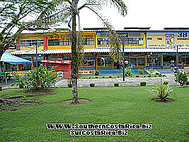
The Commercial Center of Golfito, also called Depósito Libre Comercial (Free Commercial Deposit) is unique in the country since it counts with facilities in custom broker activities and it is free of some taxes.
The creation of the Golfito Deposit was negotiated since 1986 by the Government of Costa Rica as a contingency plan after the Banana Company left.
The Deposit has 52 commercial departments, which are divided between 49 concessions, it also has two state banks and an office of the administrative institute denominated “ Junta de Desarrollo Regional de la Zona Sur” (meaning something like Regional Development Board for the South Zone), of the province of Puntarenas, (JUDESUR). If you wish more information of the Commercial Deposit of Golfito, please visit the web site “Shopping in Golfito” making Click in the Activities Section of this same site.
Golfito Geography
Golfito is located in the southeast region of Costa Rica, and it covers the Osa Peninsula, and from this it has an extension by the coast region of the Golfo Dulce ending in the border zone with Panamá. Golfito is a zone with a large extension, and it is composed by a lot of low lands that are dedicated principally to the sowing of the banana, corn, and rice, but it also has geographic irregularities with primary and secondary forests where you can find the Wild Life Refuge of Golfito (El Refugio de Vida Silvestre de Golfito) If you want to have more information about this refuge please visit the section of protected areas.
Golfito Climate, Height and Temperature
In the region of the South Pacific there are two seasons well defined, where the dry season is much more brief that the one of that showed in the North Pacific and begins in the last days of December and ends about in the month of April. The rainiest month use to be October and the driest is February, even when in this zone it is not absolutely dry like it is in the North Pacific.
The average temperatures per year go between the 25 C and the 30 C in those places that are near to the coast, however, in the summer, the temperatures go up to the 35 C, while in the higher parts of the Cordillera de Talamanca they register even the 10 C.
Be the first to comment on this listing!


- City
- Golfito